图书简介
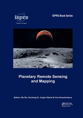
The early 21st century marks a new era in space exploration. The National Aeronautics and Space Administration (NASA) of the United States, The European Space Agency (ESA), as well as space agencies of Japan, China, India, and other countries have sent their probes to the Moon, Mars, and other planets in the solar system. Planetary Remote Sensing and Mapping introduces original research and new developments in the areas of planetary remote sensing, photogrammetry, mapping, GIS, and planetary science resulting from the recent space exploration missions. Topics covered include:Reference systems of planetary bodiesPlanetary exploration missions and sensorsGeometric information extraction from planetary remote sensing dataFeature information extraction from planetary remote sensing dataPlanetary remote sensing data fusionPlanetary data management and presentationPlanetary Remote Sensing and Mapping will serve scientists and professionals working in the planetary remote sensing and mapping areas, as well as planetary probe designers, engineers, and planetary geologists and geophysicists. It also provides useful reading material for university teachers and students in the broader areas of remote sensing, photogrammetry, cartography, GIS, and geodesy.
SECTION I: REFERENCE SYSTEMS OF PLANETARY BODIES Chapter 1 A technical framework for construction of new-generation lunar global control network using multi-mission data K. Di, B. Liu, M. Peng, X. Xin, M. Jia, W. Zuo, J. Ping, B. Wu and J. Oberst Chapter 2 Basic geodetic and dynamical parameters of Saturn’s moon Enceladus: A key target of future exploration A. Stark, H. Hussmann, J. Oberst, B. Giese, F. Sohl, D. Shoji, K. Wickhusen and M. Wahlisch Chapter 3 On the applicability of physically defined height systems for telluric planets and moons R. Tenzer and I. Foroughi SECTION II: PLANETARY EXPLORATION MISSIONS AND SENSORS Chapter 4 Comet 67P/Churyumov-Gerasimenko through the eyes of the Rosetta/OSIRIS cameras C. Guttler and the OSIRIS Team Chapter 5 The BepiColombo Laser Altimeter (BELA): An instrument for geodetic investigations of Mercury H. Hussmann, J. Oberst, A. Stark, G. Steinbrugge Chapter 6 Mars orbit optical remote sensor: High- and medium-resolution integrated stereo camera Q. Meng, D. Wang and J. Dong Chapter 7 Mission profile and design challenges of Mars landing exploration J. Dong, Z. Sun, W. Rao, Y. Jia, C. Wang, B. Chen and Y. Chu SECTION III: GEOMETRIC INFORMATION EXTRACTION FROM PLANETARY REMOTE SENSING DATA Chapter 8 Correcting spacecraft jitter in HiRISE images S. S. Sutton, A. K. Boyd, R. L. Kirk, D. Cook, J. W. Backer, A. Fennema, R. Heyd, A. S. McEwen and S. D. Mirchandani Chapter 9 Community tools for cartographic and photogrammetric processing of Mars Express HRSC images R. L. Kirk, E. Howington-Kraus, K. Edmundson, B. Redding, D. Galuszka, T. Hare and K. Gwinner Chapter 10 Photogrammetric processing of LROC NAC images for precision lunar topographic mapping B. Wu, H. Hu and W. C. Liu Chapter 11 Mercury stereo topographic mapping using data from the MESSENGER orbital mission F. Preusker, J. Oberst, A. Stark and S. Burmeister SECTION IV: FEATURE INFORMATION EXTRACTION FROM PLANETARY REMOTE SENSING DATA Chapter 12 Automatic crater detection for mapping of planetary surface age A. L. Salih, A. Lompart, P. Schulte, M. Muhlbauer, A. Grumpe, C. Woehler and H. Hiesinger Chapter 13 Small craters on the Moon: Focus on Tycho’s crater rays R. Bugiolacchi Chapter 14 Elemental and topographic mapping of lava flow structures in Mare Serenitatis on the Moon A. Grumpe, C. Woehler, D. Rommel, M. Bhatt and U. Mall Chapter 15 Mineral abundance and particle size distribution derived from in situ spectra measurements of the Chang’E-3 Yutu rover H. Lin, X. Zhang, X. Wu, Y. Yang and D. Guo SECTION V: PLANETARY REMOTE SENSING DATA FUSION Chapter 16 Fusion of multi-scale DEMs from Chang’E-3 descent and Navcam images using compressed sensing method M. Peng, W. Wen, Z. Liu and K. Di Chapter 17 Co-registration of lunar imagery and digital elevation model constrained by both geometric and photometric information B. Liu, X. Xin, K. Di, M. Jia and J. Oberst Chapter 18 Co-registration of multiple-source DEMs for correlated slope analysis at different scales on Mars Y. Wang and B. Wu SECTION VI: PLANETARY DATA MANAGEMENT AND PRESENTATION Chapter 19 Status and future developments in planetary cartography and mapping A. Nass, K. Di, S. Elgner, S. van Gasselt, T. Hare, H. Hargitai, I. Karachevtseva, E. Kersten, N. Manaud, T. Roatsch, A. P. Rossi, J. Skinner, Jr. and M. Wahlisch Chapter 20 The lunar sub-polar areas: Morphometric analysis and mapping A.A. Kokhanov, I.P. Karachevtseva, N.A. Kozlova and Zh.F. Rodionova Chapter 21 Geoportal of planetary data: Concept, methods and implementations I. P. Karachevtseva, A. S. Garov, A. E. Zubarev, E. V. Matveev, A. A. Kokhanov and A. Yu. Zharkova
Trade Policy 买家须知
- 关于产品:
- ● 正版保障:本网站隶属于中国国际图书贸易集团公司,确保所有图书都是100%正版。
- ● 环保纸张:进口图书大多使用的都是环保轻型张,颜色偏黄,重量比较轻。
- ● 毛边版:即书翻页的地方,故意做成了参差不齐的样子,一般为精装版,更具收藏价值。
关于退换货:- 由于预订产品的特殊性,采购订单正式发订后,买方不得无故取消全部或部分产品的订购。
- 由于进口图书的特殊性,发生以下情况的,请直接拒收货物,由快递返回:
- ● 外包装破损/发错货/少发货/图书外观破损/图书配件不全(例如:光盘等)
并请在工作日通过电话400-008-1110联系我们。
- 签收后,如发生以下情况,请在签收后的5个工作日内联系客服办理退换货:
- ● 缺页/错页/错印/脱线
关于发货时间:- 一般情况下:
- ●【现货】 下单后48小时内由北京(库房)发出快递。
- ●【预订】【预售】下单后国外发货,到货时间预计5-8周左右,店铺默认中通快递,如需顺丰快递邮费到付。
- ● 需要开具发票的客户,发货时间可能在上述基础上再延后1-2个工作日(紧急发票需求,请联系010-68433105/3213);
- ● 如遇其他特殊原因,对发货时间有影响的,我们会第一时间在网站公告,敬请留意。
关于到货时间:- 由于进口图书入境入库后,都是委托第三方快递发货,所以我们只能保证在规定时间内发出,但无法为您保证确切的到货时间。
- ● 主要城市一般2-4天
- ● 偏远地区一般4-7天
关于接听咨询电话的时间:- 010-68433105/3213正常接听咨询电话的时间为:周一至周五上午8:30~下午5:00,周六、日及法定节假日休息,将无法接听来电,敬请谅解。
- 其它时间您也可以通过邮件联系我们:customer@readgo.cn,工作日会优先处理。
关于快递:- ● 已付款订单:主要由中通、宅急送负责派送,订单进度查询请拨打010-68433105/3213。
本书暂无推荐
本书暂无推荐